
The roads that never were: Ten New Zealand infrastructure dreams that died on the drawing board
- Grant McLachlan

- Dec 1, 2025
- 18 min read

New Zealand’s transport network tells a story not just of what was built, but of what could have been. From alpine tunnels to urban motorways, from coastal highways to inter-island links, the country’s landscape is dotted with ghost routes—projects that made perfect sense on paper but never made it past the planning stage. These are the roads and railways that politicians promised, engineers designed, and communities needed, but that successive governments decided were too expensive, too controversial, or simply too hard.
This catalogue of infrastructure dreams deferred reveals a pattern familiar to any New Zealander: a nation that plans boldly but builds conservatively, always choosing incremental improvements over transformative change. The cost of this cautious approach? Congestion, isolation, inefficiency, and communities left quite literally at the end of the line.
1. Rerouting State Highway 1 west of Lake Taupo

State Highway 1, New Zealand’s main arterial route, takes a curious detour around Lake Taupo that adds unnecessary distance and complexity to the journey between Auckland and Wellington. The current route hugs the eastern shore of the lake through Taupo township before continuing south, creating bottlenecks and delays in what should be the country’s most efficient corridor.
The alternative—an upgraded western route bypassing the lake entirely—has been proposed multiple times over the decades but never progressed beyond feasibility studies. Sections of this route are even called Old Taupo Road. Such a route would shave significant time and distance off the journey while creating redundancy in the network. When accidents or weather close the current route through Taupo, there are no realistic alternatives for through traffic.
The engineering challenges are modest by modern standards, but the political will has never materialized. Taupo’s business community, dependent on passing trade, has consistently opposed any bypass, while the cost of new construction has deterred transport planners who prefer to incrementally upgrade the existing route. The result is a compromise that serves no one particularly well: tourists stuck in traffic, freight delayed by congestion, and locals dealing with heavy vehicles rumbling through their town.
2. Passing lanes between Cromwell and Geraldine
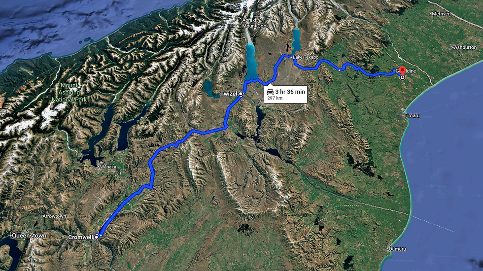
State Highway 8 connects the Southern Alps with the Canterbury Plains across 300 kilometres of stunning but challenging terrain. It’s a route beloved by tourists, essential for freight, and notorious for frustration. The problem is simple: not a single passing lane exists along the entire route, yet the traffic mix includes high proportions of trucks, buses, motorhomes, and rental vehicles driven by people unfamiliar with New Zealand roads.
The resulting slow-moving convoys are a daily occurrence. While the occasional slow vehicle pull-over lane exists, few drivers know how to use them properly, and many simply don’t bother. The absence of passing opportunities means that a single caravan or heavily-loaded truck can hold up dozens of vehicles for hours, with no safe opportunity to overtake on the winding route.
The case for adding strategic passing lanes is overwhelming. Similar upgrades on other routes have dramatically improved traffic flow and reduced accidents caused by risky overtaking manoeuvres. The terrain between Cromwell and Geraldine includes numerous suitable locations where passing lanes could be constructed without major engineering works. Yet year after year, the route remains single-lane, a monument to the gap between obvious need and funded action.
3. A Decent Road Between Nelson and Blenheim

State Highway 6 between Nelson and Blenheim should be one of New Zealand’s straightforward inter-city links. Instead, it’s a frustrating mishmash of poorly aligned corners, inconsistent maintenance standards, and bewildering speed zone changes that seem to follow no logical pattern.
The route suffers from decades of ad-hoc modifications rather than comprehensive planning. Some sections are adequate modern highway; others feel like country lanes that accidentally became state highways. Speed limits change arbitrarily, road conditions vary dramatically, and the overall journey feels far longer than the distance would suggest.
What’s needed isn’t revolutionary—just a properly planned, consistently maintained 100 km/h highway with appropriate alignment and signage. The two centres are large enough to justify a decent connection, and the terrain presents no insurmountable obstacles. But the piecemeal approach to upgrades continues, each government choosing to patch rather than properly fix, spending money without ever fully addressing the fundamental inadequacies of the route.
4. The Frankton Ring Road

Queenstown’s Frankton junction has become a cautionary tale of what happens when infrastructure planning can’t keep pace with growth. The junction now handles over 40,000 vehicles per day at peak times, and the current $250 million upgrade to replace the roundabout with traffic signals addresses symptoms rather than causes.
The fundamental problem is geometric: the majority of vehicles using the junction turn right, creating inherent inefficiency that no amount of signal timing can fully resolve. Add tourists fresh off flights who don’t know how to navigate roundabouts, and you have a recipe for chronic congestion.
The solution that should have been built—but never will be—is a second bridge across the Kawarau River. This would connect with and 80km/h Hawthorne Drive and interchange with State Highway 6 at the Lower Shotover Bridge, creating a true ring road that would relieve pressure on the Frankton junction by providing genuine alternative routes. But NZTA dismissed this option early in planning, despite it being the only solution that would actually add capacity rather than just reorganizing existing bottlenecks.
Instead, Queenstown gets traffic signals and the promise that encouraging bus use will somehow solve the problem. Meanwhile, the topography that makes a second crossing difficult remains, and so does the traffic.
5. The Remutaka Hill Road Tunnel
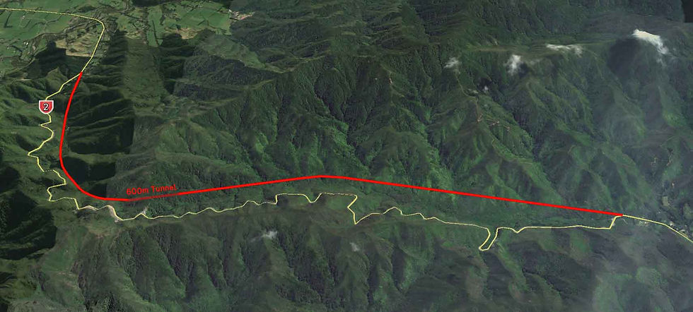
The Remutaka Hill Road is a 19th-century route that remains a critical 21st-century link. Connecting Wellington with the Wairarapa, it’s a winding, narrow passage over a mountain pass that was literally dug by hand. The route takes the most direct line—straight over the summit saddle—because that’s what made sense to surveyors with picks and shovels.
Modern engineering could do much better. A straighter alignment following the river valleys on either side, with a 600-metre tunnel through the hill, would reduce journey times by at least 15 minutes while dramatically improving safety and reliability. The current route suffers from regular closures due to crashes, breakdowns, weather, and maintenance, and there are five corners that large trucks simply cannot navigate without crossing the centreline.
The statistics are damning: between 2014 and 2023, there were 382 crashes on the route, including five fatal and 29 serious injury crashes—an average of more than three crashes per month. The road is rated New Zealand’s third most dangerous highway per kilometre, with a safety rating of just 2 out of 5 stars. Over 7,000 vehicles use it daily, including 473 heavy vehicles, and when it closes, the detour adds 200 kilometres and more than two hours to the journey.
Heavy vehicle traffic was predicted to reach 400 per day by 2028 but has already exceeded 473 per day in 2024. The fuel costs and time wasted on the current inefficient alignment run into millions annually. Yet despite decades of advocacy and comprehensive documentation of the problems, the tunnel remains a dream. The $2 billion price tag ensures it will never progress beyond the feasibility stage, leaving the Wairarapa effectively isolated every time a truck jack-knifes or weather closes the hill.
6. Auckland’s Eastern Motorway

Auckland’s motorway network was conceived in the 1950s as a four-leaf clover pattern that would serve all quadrants of the city. Only the western ring roads were built, leaving eastern Auckland in perpetual congestion with few alternative routes and no redundancy.
The missing piece—the Eastern Motorway—would have completed the network. The plan called for a connection from Spaghetti Junction through Orakei Basin to Panmure, continuing through Sylvia Park to interchange with the Southwestern Motorway north of Mangere Bridge (what’s now called the East-West Link). This would have provided the eastern suburbs with the same quality of access that western Auckland enjoys.
The original plans envisioned more than just roads. A second harbour crossing was meant to run from Stanley Point to the Grafton Valley—not parallel to the existing bridge but actually serving the eastern suburbs. This would have solved the absurd situation where Devonport and Takapuna traffic must head north to go south, crossing the harbour bridge just to reach central Auckland.
By 2004, Mayor John Banks proposed a revised version with an estimated cost of $4 billion. The community response was fierce: 1,200 houses would have been affected, established neighbourhoods would have been bisected, and the cost was equivalent to four years of the entire country’s transport budget. The project died amid protests, and the Eastern Transport Corridor designation now sits as a planning footnote, occupied by a cycle path and a busway rather than the comprehensive motorway network eastern Auckland still desperately needs.
The result is visible every day in the congestion on Tamaki Drive, Reeves Road, and Ti Rakau Drive. Eastern Auckland has grown massively but remains served by arterial roads that were never designed for current traffic volumes. The East-West Link project continues in various forms, but without the eastern motorway component, it can only ever be a partial solution.
7. State Highway 9: The ghost highway that should have completed the ring

In the New Zealand state highway numbering system, there’s a curious gap. State Highway 1 traverses the length of both the North and South Islands, 2-5 serve the North Island, 6-8 serve the South Island, 11-59 are regional routes in the north, and 60-99 are regional routes in the south. But there is no State Highway 9, nor a State Highway 81. This isn’t an oversight—it’s a placeholder for roads that were supposed to be built but never were.
State Highway 9 should have been the route that completed a loop through Fiordland, one of New Zealand’s most spectacular but inaccessible regions. The vision was ambitious: extend State Highway 6 from Jackson Bay along the coast to link with the Milford Road, then create State Highway 9 running from Milford through the Greenstone Valley to Glenorchy, Queenstown, Kingston, and on to Invercargill.
The surveys were done in the early 1900s. The Hollyford Track follows much of the proposed route from Jackson Bay to Gunns Camp. Multiple attempts were made to build roads through the area, but the engineering challenges of Fiordland—near-vertical terrain, massive rainfall, unstable geology—proved insurmountable with the technology and budgets available.
Had it been built, State Highway 9 would have created a tourist circuit rivalling anything in the world: a ring route through mountains, fiords, and lakes that would have distributed tourist traffic and created resilience in the network. Currently, the Milford Road is a dead-end that closes regularly due to avalanches and slips, stranding tourists and disrupting the tourism economy. An alternative route would have provided redundancy and opened up new areas for economic development.
But Fiordland’s protection status, the astronomical costs of building in such terrain, and the lack of population centres to serve mean State Highway 9 will remain a ghost highway—a number on a map that will never have a road to go with it.
What planning debates often overlook is that conservation value depends partly on public access and awareness. The same principle that made urban zoos vital for endangered species advocacy applies to remote wilderness: people protect what they know and value. Roads through national parks don’t just serve tourism—they create constituencies for conservation. When the public can actually experience these landscapes, they develop the political will to fund their protection. Much of the Department of Conservation’s estate consists of former Crown land that was simply too remote or difficult to develop commercially. Making strategic portions accessible through well-planned infrastructure doesn’t undermine conservation—it strengthens it by giving New Zealanders a stake in landscapes they would otherwise never see. The irony is that Fiordland’s greatest protection may lie not in its inaccessibility, but in making carefully planned routes that allow more New Zealanders to understand why such places deserve protection.
8. A Cook Strait tunnel

The idea of a fixed link across Cook Strait surfaces periodically, usually when the inter-island ferries are cancelled due to weather or when another breakdown highlights the aging fleet’s inadequacies. Critics dismiss it as fantasy; proponents point to mega-projects elsewhere: the Channel Tunnel, the Seikan Tunnel in Japan, the Øresund Bridge linking Denmark and Sweden.
The basic case is more compelling than critics acknowledge: the Cook Strait ferries currently carry about one million passengers and 230,000 vehicles annually, plus three to four million tonnes of cargo. Revenue from sea traffic alone exceeds $1 billion annually. But these figures represent constrained demand—what people are willing to endure given current limitations, not what traffic would be if crossing the strait was as simple as driving through a tunnel.
The most instructive comparison is the Confederation Bridge linking Prince Edward Island with New Brunswick in Canada. Before the bridge opened in 1997, PEI had a population of 140,000 and New Brunswick 750,000—comparable to Wellington/Manawatu (725,200) and Nelson/Marlborough/North Canterbury (120,000). The bridge didn’t just serve existing traffic; it transformed the regional economy. Tourist visits jumped from 740,000 to 1,200,000 in the first year and stabilized around 900,000 annually. Daily traffic now averages 4,000 vehicles—far more than pre-bridge ferry usage would have predicted.
A Cook Strait tunnel would trigger similar transformative growth. The upper South Island, currently economically constrained by ferry dependence, would become effectively connected to the national economy. Commuting between Wellington and Marlborough would become viable. Freight costs would drop dramatically—no more waiting for ferry schedules, no more cancellations due to weather, no more paying premium rates for a service that operates at capacity. Living costs in Nelson, Blenheim, and the upper South Island would fall as reliable access to Wellington’s economy reduced isolation premiums.
A tunnel linking Picton and Wellington would be 66.6 kilometres—longer than the Channel Tunnel but similar to Japan’s Seikan Tunnel, which has survived numerous earthquakes. Based on comparable projects, construction costs would likely reach $15-20 billion in current dollars. Two bores would be needed: a pilot tunnel for maintenance and escape, and a main tunnel potentially carrying both road and rail traffic on separate levels. The engineering is proven—the Seikan Tunnel demonstrates that long undersea tunnels can be built and maintained in seismically active zones.

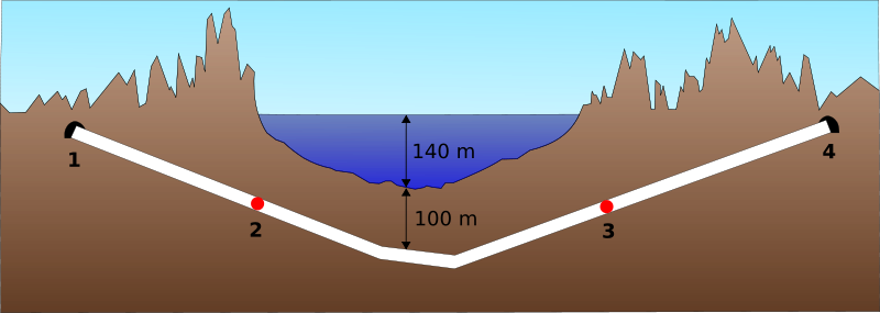


The earthquake risk, while real, is manageable with proper engineering. The shortest practical route would avoid the major fault lines, staying west of the continental fault. The spoil from tunnelling could extend Wellington Airport’s runway, expand port facilities, and reclaim land—creating additional economic value beyond the tunnel itself.
The real barrier isn’t engineering or even cost—it’s the failure to account for induced demand and network effects. Traditional cost-benefit analysis looks at current traffic and concludes the numbers don’t justify the investment. But this fundamentally misunderstands how transformative infrastructure works. The Channel Tunnel didn’t just serve existing ferry passengers; it created entirely new patterns of commerce, commuting, and connection. The Confederation Bridge didn’t just replace a ferry; it integrated an island economy with the mainland.
A Cook Strait fixed link would similarly transform rather than just serve. It would create network resilience—when one route is blocked, alternatives exist. It would enable sharing of utilities beyond just electricity. It would make the upper South Island viable for industries that currently can’t accept the risk and cost of ferry dependence. Most importantly, it would lower the cost of freight and living across both regions, generating economic benefits that compound over decades.
The tunnel will never be built because New Zealand’s infrastructure planning remains trapped in a paradigm that can only see current traffic volumes, not transformative potential. The same mindset that declared the Auckland Harbour Bridge didn’t need clip-on lanes, that Auckland’s motorway network could stop at the Western Ring Route, that rail to the regions wasn’t economically justified. By the time the inadequacy of ferry services becomes undeniable—probably after a major failure strands thousands—the project will be vastly more expensive and disruptive than if it were built proactively.
9. A dual carriageway between Havelock North and Hastings
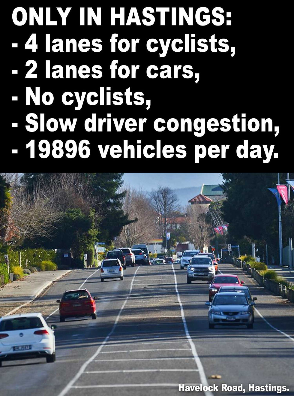
Hastings has systematically undermined its own road network through decades of poor planning. While Napier developed a hub-and-spoke system with multiple dual carriageways linking the centre to suburbs like Taradale, Hastings took its natural grid system—which should have provided numerous alternative routes—and progressively blocked intersections, creating cul-de-sacs and forcing traffic onto fewer and fewer main routes.
The result is that Hastings has only one dual carriageway: St Aubyn Street. Meanwhile, the connection between Hastings and Havelock North, which carries 20,000 vehicles per day (Napier’s Taradale Road and Kennedy Road combined traffic is under 30,000 vehicles), remains a single carriageway.
The corridor is 23 metres wide—adequate for a proper dual carriageway—yet the roading is configured with four lanes for cyclists and only two for vehicles along the 70 km/h stretch. The two-lane roundabouts have become de facto passing lanes, with drivers using them to overtake slower traffic.
Havelock North has a population of 15,000, making it larger than many towns served by dual carriageways. The traffic volumes and corridor width both support upgrading to dual carriageway, which would improve safety, reduce congestion, and provide better service to both communities. But Hastings’ commitment to cycling infrastructure—regardless of actual usage patterns or traffic demands—means this sensible upgrade will never happen. Instead, cars and trucks queue behind each other while empty cycle lanes run parallel, a monument to ideology over practicality.
10. The East Coast Main Trunk Railway
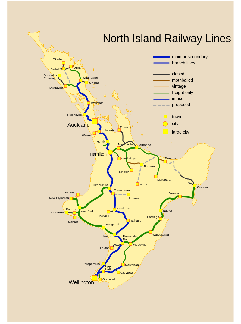
The East Coast Main Trunk Railway was meant to link Opotiki to Gisborne, completing a rail loop around the eastern Bay of Plenty and allowing through freight traffic between Auckland, the Bay of Plenty, and the East Coast. Construction began in the early 20th century, with routes surveyed and cuttings dug, but work stopped in 1928. The Taneatua branch was mothballed in 2003 and the Moutohora Branch in 1959.
Most of the old railway cuttings remain, meaning much of the earthworks are already done. With modern construction technology, completing the link should be simpler and cheaper than the original project. But instead of building new railways, New Zealand has spent recent decades closing them.
The rail connection between Gisborne and Napier has been repeatedly damaged by weather events and, rather than properly repair it, successive governments have mothballed sections. Gisborne, one of New Zealand’s most isolated cities, has been left quite literally at the end of the line.
Completing the East Coast Main Trunk would transform the economics of the region. Instead of trains returning empty to Gisborne, freight could continue through to Tauranga and Auckland. The forestry expansion planned for the East Coast—part of the government’s billion trees program—will generate massive freight volumes that the roads and port cannot handle efficiently. Rail would provide the capacity, but by the time the trees mature and need transporting, it will be too late to build the infrastructure at reasonable cost.
The pattern is familiar: plant trees now, realize a decade later that there’s no way to transport them economically, then spend vastly more in a rush to build the infrastructure that should have been constructed in advance. A completed eastern rail loop could serve tourism, provide redundancy for freight, and open up economic opportunities for a region that has been systematically overlooked. The economic and social case is strong, but the political will is absent.
The pattern of neglect
These ten projects—ranging from modest upgrades to transformative mega-projects—share common themes. They were all identified by competent engineers as solving real problems. They all faced opposition, whether from local communities protecting their turf, politicians afraid of the price tag, or bureaucracies more comfortable with incremental tinkering than bold construction.
Most tellingly, they represent roads and railways that would have made New Zealand more connected, more resilient, and more efficient. The Remutaka Tunnel would have linked Wellington and the Wairarapa properly. The Eastern Motorway would have completed Auckland’s network. State Highway 9 would have opened up Fiordland. The East Coast railway would have served a region that continues to be isolated and economically disadvantaged.
The invisible hand of political economics
The consistent pattern across these failed projects reveals more than technical planning failures—it exposes the political economy that shapes infrastructure decisions in small democracies. New Zealand’s size creates unique dynamics that systematically favour incremental spending over transformative investment, regardless of what planning documents recommend.
In larger countries, major infrastructure projects create geographically concentrated benefits that generate strong political constituencies. A bridge linking two major population centres creates millions of beneficiaries who will notice and remember the improvement. In New Zealand, even the largest projects serve relatively small populations. The entire upper South Island has fewer people than a single outer suburb of Sydney or Melbourne. This creates a political dynamic where concentrated costs (visible price tags, land acquisition, construction disruption) face diffuse benefits spread across a small population.
The result is that infrastructure investment gravitates toward projects with visible, immediate impacts in politically important areas. Widening existing urban motorways serves hundreds of thousands of daily users who experience tangible time savings. Building a tunnel through Fiordland or completing a rail line to Gisborne serves far fewer people with benefits that accrue slowly over decades. Politicians facing three-year electoral cycles rationally prefer the former, even if long-term economic returns favour the latter.
This dynamic is reinforced by New Zealand’s funding mechanisms. Infrastructure is largely funded from general taxation or specific charges like fuel taxes and road user charges, creating a tragedy of the commons where every region wants investment but resists contributing to projects that primarily benefit other regions. Auckland ratepayers question why they should fund rail to Gisborne. Wellington commuters wonder why national fuel taxes should pay for Queenstown’s ring road. The result is that only projects with nearly universal support or those serving major population centres can secure funding.
The institutional structure compounds these problems. Transport agencies are tasked with optimizing existing networks, not reimagining them. Their expertise, incentives, and organizational culture all point toward incremental improvement of established routes.
Proposing a completely new highway through Fiordland or a Cook Strait tunnel requires skills and perspectives these organizations don’t cultivate. Engineers can design such projects, but the institutions lack the economic development expertise, regional planning integration, and political entrepreneurship needed to champion transformative infrastructure.
Risk aversion plays a crucial role. Incremental projects have predictable costs, established construction methods, and proven benefits. Transformative projects carry uncertainty in every dimension: construction costs can overrun dramatically, technical challenges may prove more difficult than anticipated, and projected benefits may not materialize. For bureaucrats and politicians alike, the safest choice is the one that won’t make headlines if it fails. A botched intersection upgrade is embarrassing; a failed multi-billion dollar tunnel is career-ending.
Perhaps most insidiously, New Zealand has developed what might be called "infrastructure learned helplessness." Decades of deferred major projects have created a political culture where transformative infrastructure is simply not considered realistic. When the Cook Strait tunnel is discussed, it’s treated as a thought experiment rather than a serious proposal. When State Highway 9 through Fiordland is mentioned, it’s quickly dismissed as environmentally impossible. The conversation never advances to serious technical and economic evaluation because the political culture has predetermined the answer.
This creates a vicious cycle: transformative projects aren’t built because they’re not politically viable, and they’re not politically viable because no one believes they can be built. Meanwhile, incremental projects accumulate, each one rational in isolation but collectively insufficient to address fundamental network inadequacies. The country ends up spending billions on continuous upgrades to the Remutaka Hill Road rather than considering whether a tunnel would ultimately be more cost-effective.
The compounding cost of path dependency
The decisions not to build these projects have created a form of infrastructure path dependency that becomes more expensive to reverse with each passing year. Path dependency—the economic principle that past decisions constrain future options—operates with particular force in transport networks, where every road built (or not built) shapes subsequent development in ways that become increasingly difficult to undo.
Consider Auckland’s eastern suburbs. When the Eastern Motorway was abandoned in the 2000s, development didn’t stop—it simply proceeded without adequate transport infrastructure. Residential subdivisions, commercial centres, and industrial parks were built assuming the existing arterial road network. Property values, business locations, and commuting patterns all adapted to this constrained reality. Now, building the Eastern Motorway would require acquiring land that has since been developed, demolishing buildings that didn’t exist when the route was first planned, and disrupting communities that organized themselves around the assumption the motorway would never be built.
The same dynamic applies to the Cook Strait tunnel. Every year that passes without a fixed link, more investment flows into ferry infrastructure, port facilities, and logistics operations designed around the ferry system. KiwiRail orders new ferries, ports upgrade their ferry terminals, freight companies optimize their operations for sailing schedules. Each of these investments creates a constituency with a vested interest in maintaining the status quo. The tunnel becomes not just an engineering and financial challenge but a political one: how do you justify stranding billions in relatively recent ferry-dependent investments?
This creates a perverse dynamic where delay makes projects progressively more expensive in both financial and political terms. The Remutaka Hill tunnel would have been straightforward to build in the 1950s when land acquisition costs were minimal and environmental regulations were light. Building it now requires navigating complex environmental assessments, acquiring land at urban prices, and managing construction disruption for a region that has organized itself entirely around the existing route. The project hasn’t become more expensive just due to inflation—it’s fundamentally harder because the region has adapted to the inadequate infrastructure.
Regional economic development suffers from similar path dependency. Gisborne’s economy has adapted to isolation: the region specializes in industries that can tolerate high freight costs (like wine and premium produce) and accepts that it won’t attract industries requiring reliable, high-volume transport (like manufacturing or distribution). This adaptation then becomes the justification for not improving infrastructure: "Gisborne doesn’t have much freight anyway, so rail isn’t needed." But Gisborne doesn’t have freight-intensive industry precisely because the rail infrastructure doesn’t exist. The cause and effect run in circles, with each iteration making the original infrastructure deficit harder to justify addressing.
The fiscal implications extend beyond simple project costs. New Zealand’s infrastructure funding model relies heavily on user charges—fuel taxes and road user charges—which creates a problem when trying to fund new routes. Existing infrastructure generates revenue that pays for its maintenance and incremental improvement. New infrastructure requires capital that won’t generate user charge revenue until it’s built and operating. This creates a built-in bias toward upgrading existing routes over building new ones, even when new routes would be more economically efficient in the long term.
Perhaps the least visible but most damaging cost is what economists call the "option value" that’s been lost. When the Eastern Motorway designation was abandoned, Auckland didn’t just lose a road—it lost the option to build that road in the future without massive demolition. When State Highway 9 through Fiordland was deemed permanently unviable, New Zealand lost the option to respond to future tourism growth or climate change impacts on existing routes. These lost options don’t appear in any government accounts, but they represent real economic value: the flexibility to adapt to circumstances that can’t be foreseen.
The intergenerational dimension is particularly stark. Today’s adults inherited an infrastructure network largely built by previous generations—the Kaimai Tunnel, the Auckland Harbour Bridge, the Lyttleton Tunnel. These assets continue delivering value decades after their construction costs were paid. Today’s generation, by choosing incremental spending over transformative investment, is bequeathing future New Zealanders a network that’s only marginally better than what they inherited, while land costs and construction complexity have made the transformative projects they deferred potentially unbuildable at any price.
There’s a broader philosophical question embedded in these deferred projects: what is infrastructure for? If it’s merely to serve existing demand, then incremental improvements to busy routes make sense. But if infrastructure is meant to enable economic development, create opportunities for regions currently disadvantaged, and provide resilience against disruptions, then New Zealand’s approach has been systematically inadequate. The country has treated infrastructure as an expense to be minimized rather than an investment that shapes national development for generations.
These ten projects—from modest passing lanes to transformative tunnels—represent more than missed opportunities. They’re symptoms of a political and planning culture that has lost the ability to think generationally about infrastructure. Until New Zealand rediscovers the vision that built the Kaimai Tunnel and the Auckland Harbour Bridge, that planned the original motorway network and the Think Big projects, the list of should-have-been roads and railways will only grow longer. Future generations will look back not just at the projects we failed to build, but at the prosperity we failed to enable and the connections we failed to create.


