
Drowning in its own harbour: How Auckland's Waitemata Harbour crossings epitomise everything wrong with Auckland politics
- Grant McLachlan

- Mar 2
- 19 min read

In the history of large Western democracies, few cities of comparable size have managed to so comprehensively, repeatedly, and expensively fail themselves on a single piece of infrastructure as Auckland has with the crossing of its own harbour. The Waitemata Harbour is not a vast or treacherous body of water — it is barely a kilometre wide at the bridge point. Sydney crosses a harbour roughly five times wider. Yet Auckland has spent more than 160 years proposing, debating, diluting, striking, abandoning, reproposing, and — when absolutely forced into action — importing the competence to build what it should have built right the first time.
Contents
PART ONE
Sydney builds the unimaginable — then does it again
PART TWO
Auckland builds a bridge too small, then imports the fix
PART THREE
Two Mangere bridges — a study in institutional learning
PART FOUR
The second crossing — 160 years and counting
PART FIVE
Flying blind — the data deficit that makes everything worse
PART SIX
Vested interests, vested interests, and vested interests
CONCLUSION
This is not a story of engineering impossibility. It is a story of political failure: of austerity thinking, union militancy, territorial vested interests, and an institutional inability to collect even the most basic data needed to make rational decisions. It is a story that explains why the great infrastructure projects in Auckland's history were either built by someone else — or never built at all.
The harbour bridge is the wound. The proposed second crossing is the scar tissue. And the politics that produced both is the disease.
PART ONE:
Sydney builds the unimaginable — then does it again
A bridge first proposed in 1815
When convict architect Francis Greenway proposed a bridge across Sydney Harbour to Governor Lachlan Macquarie in 1815, he was thinking about the future of a settlement that had barely 10,000 people. Nothing came of it, but the idea refused to die. For the next hundred years, proposals multiplied: a floating bridge in 1840, serious engineering drawings from Peter Henderson in 1857, a truss bridge concept in 1879, an international design competition in 1900. A Royal Commission examined the question in 1890 and again as the century turned.
John Bradfield became Chief Engineer of Sydney Harbour Bridge and Metropolitan Railway Construction in 1912 and never let the dream die. In 1916, the NSW Legislative Assembly passed a bill authorising construction. The Legislative Council killed it — not because the bridge was a bad idea, but because the money was needed for World War I. By 1922, the Sydney Harbour Bridge Act had passed. By 1924, the contract was awarded to the English firm Dorman Long & Co of Middlesbrough — the same company that had built the Tyne Bridge. By 1932, it was done.
Sydney Harbour Bridge — key facts • First seriously proposed: 1815 (Francis Greenway to Governor Macquarie) [source] • First international design competition: 1900 [source] • Legislation passed: 1922 (Sydney Harbour Bridge Act) [source] • Contract awarded to Dorman Long & Co: March 1924 [source] • Opened: 19 March 1932 — eight years from contract [source] • Total length: 1,149 metres | Main arch span: 503 metres [source] • Width: 49 metres — includes 4 rail tracks, 8 road lanes, and pedestrian walkways both sides [source] • Cost: AU£6.25 million (not fully repaid until 1988) [source] |
The Sydney Harbour Bridge is not merely a road crossing. From the day it opened, it carried four rail tracks as part of an integrated vision of a connected metropolitan region. There are pedestrian walkways on both sides. The structure is 49 metres wide and was designed by Bradfield explicitly to serve multiple transport modes, because Bradfield understood that a harbour crossing is infrastructure for a century, not a decade.
New South Wales dreamed big and built bigger. From first serious proposal to opening day, the timeline ran approximately 115 years in ambition and eight years in construction. The bridge was built by an English firm, using Australian steel, employing over 1,400 workers, enduring the Great Depression, and still coming in on budget.

Sydney's second crossing: a tunnel built in four years
By 1982 — exactly fifty years after the bridge opened — it was clear that Sydney needed a second harbour crossing. The bridge was carrying around 160,000 vehicles per day, and projections showed 240,000 by 2000 without intervention.
A tunnel had been suggested as early as 1885, when two Sydney businessmen proposed twin tunnels for trams and horses at their own expense, offering to recoup costs through tolling. The government rejected the plan as too dangerous. In 1979, a new round of proposals for bridges and tunnels was called. All were rejected because demolishing established neighbourhoods was politically unacceptable.
The solution came from the private sector. In 1984, engineering consultants Wargon Chapman Partners approached Transfield with a proposal for an immersed-tube tunnel beneath the harbour. Transfield and Japanese construction giant Kumagai Gumi spent $4 million developing the proposal before approaching government. Cabinet approved the contract in April 1987. The agreement was signed in June 1987.
Construction began in January 1988. The Sydney Harbour Tunnel opened on 14 August 1992 — just four and a half years after breaking ground. Total cost: approximately A$750 million. The tunnel is 2.3 kilometres long, carries two lanes in each direction, and by 2017 was handling around 96,000 vehicles per day.
Sydney Harbour Tunnel — key facts • First proposed: 1885 (twin tram/pedestrian tunnels by private investors) [source] • Modern proposal developed: 1984 (Transfield/Wargon Chapman Partners) [source] • Government contract signed: June 1987 [source] • Construction began: January 1988 [source] • Opened to traffic: 14 August 1992 [source] • Construction period: 4.5 years from contract to opening [source] • Total length: 2.3 km (1 km underwater immersed tube) [source] • Cost: approximately A$750 million — privately financed (BOT) [source] • Daily traffic by 2017: approximately 96,000 vehicles [source] |
From concept to ribbon-cutting, Sydney built its second harbour crossing — a twin-tube tunnel beneath a major working harbour — in under five years, privately financed, on budget, and functional from day one. Sydney identified the problem, found a private consortium willing to take the financial risk, got out of the way, and let competent engineers and builders do the work.
Sydney has not stopped. Even as Auckland commissions its latest round of reports, Sydney is simultaneously building two new harbour crossings. The Western Harbour Tunnel — twin three-lane road tunnels running 6.5 kilometres from Rozelle to Cammeray — has been under construction since 2021 and is due to open in 2028, becoming the city's third road crossing of the harbour. Alongside it, the Sydney Metro West project is boring a second rail tunnel beneath the harbour — a 2.3-kilometre crossing from The Bays through Pyrmont to Hunter Street — following the Metro City & Southwest line, which opened in August 2024 as Sydney's first rail harbour crossing. Metro West is due to open in 2032. By then, Sydney will have five harbour crossings — two bridges and three tunnels, including two rail links. Auckland, which has been debating its second road crossing since the 1970s, will still be deciding whether to start.
Auckland, meanwhile, was still arguing about whether it needed to do anything at all.
PART TWO:
Auckland builds a bridge too small, then imports the fix
The penny-pinching original
Auckland's harbour crossing problem was identified long before anyone seriously attempted to solve it. As early as 1860, engineer Fred Bell had proposed a floating pontoon crossing for North Shore farmers wanting to drive their livestock to Auckland markets. The estimated cost of £16,000 was deemed too high. That judgment would define Auckland's relationship with its own harbour for the next 165 years.
By the mid-twentieth century, the situation demanded action. A Royal Commission in 1930 and another in 1946 both examined the harbour crossing question. The 1946 Commission recommended a bridge of five or six lanes, with reversible peak-direction lanes, and pedestrian footpaths on both sides. It further recommended that any bridge be capable of accommodating rail.
The National Government of Prime Minister Sidney Holland had a different view. The total budget could not exceed £5 million. What resulted was an 'austerity' design: four lanes, no pedestrian access, no cycling provision, and absolutely no rail capacity. The decision has been described as "a ringing testament to the peril of short-term thinking and penny-pinching."
The bridge was built between 1955 and 1959 by Dorman Long — the same English firm that had built the Sydney Harbour Bridge — with the Cleveland Bridge & Engineering Company as co-contractor. Work was frequently interrupted by strikes in 1956 and 1957. Four workers died during construction. The bridge opened on 30 May 1959 at a cost of £7.5 million — already more than the government's original cap.
In its first year alone, the bridge carried an average of 13,493 vehicles per day. Planners had projected 8,250 per day by 1965. The bridge was already running 63 percent over forecast in its opening year. The austerity four-lane design was obsolete before the concrete had properly cured.
Auckland Harbour Bridge — the original (1959) • First crossing proposed: 1860 (Fred Bell's floating pontoon — rejected as too expensive) [source] • Royal Commissions: 1930 and 1946 [source] • 1946 Commission recommendation: 5-6 lanes, reversible, pedestrian paths, rail-capable [source] • Government decision: 4 lanes only, no pedestrians, no cycling, no rail — 'austerity' design [source] • Construction period: 1955–1959 (4 years, plagued by strikes) [source] • Opened: 30 May 1959 [source] • Cost: £7.5 million (over the original budget cap of £5 million) [source] • Projected daily traffic by 1965: 8,250 vehicles [source] • Actual daily traffic in first year: 13,493 vehicles — 63% over forecast [source] |
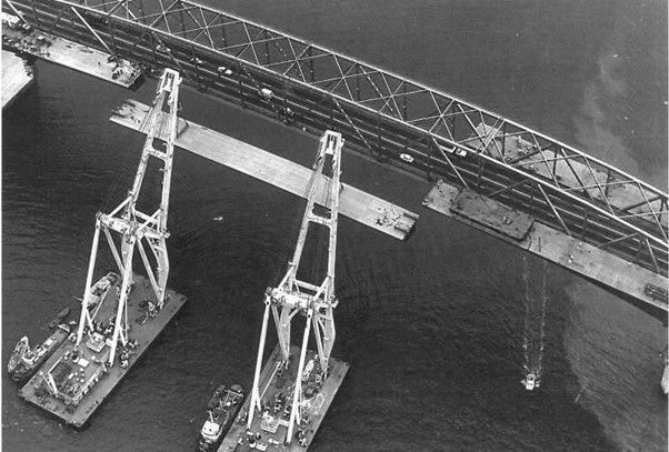
The Nippon clip-ons: outsourcing competence
Within a decade of opening, the four-lane bridge was wholly inadequate. Adding two lanes to each side would double its capacity — but doing so required a contractor capable of prefabricating huge steel box-girder sections and attaching them to the existing bridge structure without closing it.
New Zealand's construction unions in the 1960s were among the most militant in the developed world, prone to disputation, work stoppages, and jurisdictional warfare. The solution was to classify the clip-on project as a maritime project — a classification that removed it from the normal framework of New Zealand industrial relations and union jurisdiction. This meant the work could be contracted to a foreign firm operating under different rules.
The contract went to Ishikawajima-Harima Heavy Industries of Japan — a bold choice, as anti-Japanese sentiment remained real in New Zealand barely twenty years after World War II. The Japanese firm prefabricated the box-girder extensions in Japan, shipped them to Auckland, and attached them using cutting-edge orthotropic box-structure technology. The eastern section was completed in January 1969; the western in September the same year. The bridge's capacity doubled from four lanes to eight. The project came in under budget.
The nickname 'Nippon clip-ons' was partly a nod to the Japanese manufacturer and partly an acknowledgment that New Zealand had to go offshore to get a difficult job done properly. It was not the last time Auckland would discover that the surest way to accomplish something was to put it beyond the reach of the forces that would otherwise destroy it.
The Nippon clip-ons (1968–1969) • Need identified: immediately — bridge over capacity by 1960 [source] • Classification: Designated 'maritime project' to avoid NZ union jurisdiction [source] • Contractor: Ishikawajima-Harima Heavy Industries, Japan [source] • Technology: Orthotropic box-structure — cutting-edge for the mid-1960s [source] • Eastern side completed: January 1969; western side: September 1969 [source] • Result: Bridge lanes doubled from 4 to 8 — came in under budget [source] • Later issues: Fatigue cracking discovered 1985; major repairs 1986–1989 [source] • Note: Designed in New Zealand — the Japanese firm built them [source] |
The lesson of the clip-ons is instructive: when New Zealand gets out of its own way and gives a technically complex project to an organisation capable of executing it, things get done on time and within budget. When New Zealand's own industrial, political, and institutional forces are allowed to shape delivery, the results are predictably disastrous.

PART THREE:
Two Mangere bridges — a study in institutional learning
The first Mangere motorway bridge: New Zealand's longest industrial dispute
If the Nippon clip-ons demonstrate what happens when you remove New Zealand's labour politics from the equation, the first Mangere motorway bridge demonstrates what happens when you don't.
By the early 1970s, Auckland needed a motorway-grade crossing of the Manukau Harbour. In 1972, preliminary earthworks began. Two contracts were let: one for foundations in January 1973, and one for the bridge structure awarded to Wilkins & Davies Development Company in July 1974. Completion was expected by July 1978.
Industrial action began as early as 1975, becoming increasingly regular over the following years. In May 1978, with the bridge nearly complete, construction halted entirely. The immediate trigger was a redundancy dispute: 142 carpenters and labourers faced lay-offs. They sought to renegotiate redundancy terms as permitted under their original agreement. The company refused — and then sacked all 142 workers.
What followed was the longest continuous industrial dispute in New Zealand's history. The workers picketed the site. The company refused to negotiate. The Master Builders Association backed the company. The Muldoon government amended the Social Security Act specifically to deny the locked-out workers unemployment benefits — even as paying Wilkins & Davies $30,000 a month in 'maintenance' costs for a bridge on which no work was being done.
The standoff lasted two and a half years. The number of picketers eventually dwindled to sixteen. Wilkins & Davies' contract was suspended in July 1978; a new contract was awarded to Fletcher Construction in November 1980. The bridge, originally due to open in 1977, finally opened in February 1983 — six years late. Industrial disputes had quadrupled the original cost estimate.
First Mangere motorway bridge — the industrial disaster • Construction started: 1972 (earthworks); structure contract July 1974 [source] • Scheduled completion: July 1978 [source] • Industrial action began: 1975, escalating through 1977 [source] • Longest NZ industrial dispute began: May 1978 — 142 workers sacked over redundancy [source] • Picket maintained for: 2.5 years (dwindled to 16 picketers at the end) [source] • Original contract suspended: July 1978 [source] • New contract (Fletcher Construction): November 1980 [source] • Bridge finally opened: February 1983 — SIX YEARS LATE [source] • Cost impact: Industrial disputes quadrupled the original estimate [source] |
The second Mangere bridge: what happens when you get it right
By 2000, the 1983 bridge was carrying 80,000 vehicles per day and had become chronically congested. A second, parallel bridge was needed. In 2006, the government announced funding; by April 2008, construction had formally begun.
Rather than a conventional adversarial contract, the project was delivered through an alliance model: the MHX Alliance, combining the NZ Transport Agency, Beca Infrastructure, Fletcher Construction, and Higgins Contractors in a collaborative framework where all parties shared risk and reward.
The second Mangere Bridge — doubling total capacity to ten lanes including two bus shoulder lanes — was completed on 25 July 2010, seven months ahead of schedule.
The same harbour. Similar engineering challenges. In 1974-1983, the project ran six years late and cost four times the estimate. In 2008-2010, the project ran seven months early. The difference was not engineering. The difference was governance.
Second Mangere bridge — the alliance success • Need identified: by 2000 (80,000 vehicles/day, chronic congestion) [source] • Funding announced: 2006 [source] • Construction began: April 2008 [source] • Completed: July 2010 — SEVEN MONTHS AHEAD OF SCHEDULE [source] • Delivery model: MHX Alliance (NZTA + Beca + Fletcher + Higgins) [source] • Result: 10 lanes total across harbour, including 2 bus shoulder lanes [source] |
PART FOUR:
The second crossing — 160 years and counting
A history of proposals, reports, and nothing
The Auckland Harbour Bridge was designed, from its reduced 'austerity' form, to be over capacity within roughly two decades. The Nippon clip-ons bought some time. Planners in the early 1970s predicted the expanded eight-lane bridge would be at capacity by approximately 1985. They were roughly right. Already by the 1970s, proposals for a second harbour crossing were circulating — including a bridge from Meola Reef to Birkenhead, abandoned after public outcry.
Since then, Auckland has produced an extraordinary volume of studies, commissions, reports, options analyses, business cases, indicative business cases, preferred options, and announcements about future studies. What it has not produced is a second harbour crossing.
A partial list of the key moments of almost-action:
1970s: Meola Reef to Birkenhead bridge proposal — abandoned after community opposition. [source]
2004: Mayor John Banks proposes an eastern motorway including a second harbour crossing from Stanley Point to the Grafton Valley, estimated at $4 billion. Killed by community opposition. [source]
2011: Auckland Council's ten-year transit plan explicitly prioritises alternatives that delay or avoid the need for a second crossing. [source]
2016: SkyPath walking/cycling add-on receives Council funding approval and planning consent. Not built. [source]
2019/2020: Business case for Additional Waitematā Harbour Crossing (AWHC) completed. [source]
2021: Northern Pathway (dedicated walking and cycling bridge) announced. Not built. [source]
March 2023: Labour government presents five crossing scenarios costing $20–45 billion. Construction to begin 2029. Labour loses the November 2023 election. [source]
2024: Auckland Mayor Wayne Brown proposes a new bridge from Meola Reef to Kauri Point — described as landing on 'a swampy shoreline adjacent to an ammunition dump.' [source]
March 2025: The current National government announces two three-lane road tunnels. Total project cost: NZ$35–45 billion. Construction timeline: still to be determined. [source]
Auckland's second crossing — in numbers • First seriously proposed: early 1970s (Meola Reef bridge) [source] • Number of major studies since: at least ten over 30 years (Waka Kotahi estimate) [source] • Cost of 2023 Labour proposal: NZ$35–45 billion (road and rail tunnels) [source] • Cost of 2025 National proposal: NZ$35–45 billion (road tunnels only, no light rail) [source] • Sydney Harbour Tunnel (built 1988–1992): A$750 million [source] • Years elapsed since second crossing was first seriously needed: 50+ [source] • Status: Still not started [source] |
The contrast with Sydney is damning. Sydney identified the need for a second crossing, had it privately designed and proposed, executed it through a build-operate-transfer arrangement, and opened it in under five years for $750 million in 1992 dollars. Auckland has spent fifty years generating reports, arguing about crossing type, fighting over routes, changing governments, and is now staring at a price tag of up to $45 billion — nearly sixty times the cost of Sydney's tunnel in comparable terms — for a project that has still not broken ground.

The eastern motorway and what might have been
The full story of Auckland's second harbour crossing cannot be told without understanding what the original planners envisioned for the city's east. The original plans envisioned more than just roads. A second harbour crossing was meant to run from Stanley Point to the Grafton Valley — not parallel to the existing bridge but actually serving the eastern suburbs. This would have solved the absurd situation where Devonport and Takapuna traffic must head north to go south, crossing the harbour bridge just to reach central Auckland.
That eastern crossing — planned as part of the Eastern Motorway network that would have connected Spaghetti Junction through Orakei Basin to Panmure and beyond — was killed by community opposition and a $4 billion price tag in 2004. By abandoning the eastern crossing, Auckland not only failed to provide the North Shore with relief — it also failed eastern Auckland entirely. The option value lost in 2004 cannot be recovered at any price.
PART FIVE:
Flying blind — the data deficit that makes everything worse
We don't even know where the traffic comes from
Underneath all of the political failure, the strategic incoherence, and the institutional incompetence lies something almost absurdly simple: New Zealand's roading authorities do not have the basic data needed to determine what kind of second crossing Auckland actually needs.
Consider Lake Road, on Auckland's North Shore — one of the most congested arterials in New Zealand, running through Devonport and Takapuna. It connects directly to the Northern Motorway which feeds the Auckland Harbour Bridge. Yet nobody — not NZTA, not Auckland Transport, not any government agency — knows with any precision how much of Lake Road's peak traffic eventually makes its way onto the bridge heading south. How much is local? How much is through-traffic headed to the CBD or beyond?
The technology to answer this question has existed for well over a decade. Automatic number plate recognition cameras positioned at Lake Road's entry and exit points, cross-referenced with cameras at the bridge, would allow planners to model origin-destination flows with genuine precision. A comprehensive licence plate survey across the bridge's approaches would reveal exactly where Auckland Harbour Bridge traffic comes from and where it goes.
Instead, New Zealand has spent millions of dollars on modelling exercises that are, by definition, theoretical — models built on assumptions, calibrated to data that is itself estimated, producing outputs that can be manipulated to support almost any conclusion a political master desires. The absence of empirical data does not just make planning harder. It makes planning political.
Traffic models are only as good as the data that feeds them. When that data is estimated rather than measured, models become instruments of advocacy rather than tools of analysis. Every special interest group gets to commission its own model showing its preferred outcome is optimal.
The licence plate technology needed to run these surveys is not experimental — it is the same technology used in automated tolling, red-light cameras, and parking enforcement across the developed world. A comprehensive origin-destination survey of Auckland Harbour Bridge traffic could be completed in weeks and would cost a fraction of a percent of what has already been spent on business cases and planning reports. The fact that this survey has not been conducted — and apparently has never been seriously proposed as a prerequisite — is not an oversight. It is symptomatic of a planning culture more comfortable with expensive uncertainty than with cheap clarity.
PART SIX:
Vested interests, vested interests, and vested interests
The three words that explain everything
The late Sir Dove-Myer Robinson — 'Robbie' — served as Mayor of Auckland from 1959 to 1965 and again from 1968 to 1980. He championed 'Robbie's Rapid Rail' — a comprehensive rapid transit network for Auckland with detailed modelling, patronage projections, and route alignments that Auckland is still more or less trying to approximate through the City Rail Link, fifty years later.
The plan was killed. Labour promised to fund it in 1972 and didn't. National killed it outright in 1976.
When asked why — why, in a city clearly growing beyond its arterial road network, a plan that would have transformed Auckland's liveability for generations had been defeated — Robbie's reported answer was a masterpiece of frustrated clarity: "Vested interests, vested interests, and vested interests."
The quote was not merely rhetorical. It was a precise diagnosis. The forces arrayed against transformative Auckland infrastructure in the 1970s were the same forces that had killed bold harbour bridge design in the 1950s, the same forces whose union militancy had made the clip-ons necessary and had turned the Mangere Bridge into a six-year disaster, and the same forces that would continue to prevent, delay, dilute, or derail every significant piece of infrastructure Auckland has needed since.
What are these vested interests? They are multiple and mutually reinforcing. The property interests of established neighbourhoods that resist any change to their immediate environment. The industrial interests that see major construction projects as opportunities for disputation and wage extraction. The political interests of governments unwilling to make enemies by actually deciding anything. The institutional interests of agencies whose reason for existence is managing existing assets rather than creating new ones. The consultant interests that profit from continued uncertainty — because every cancelled and restarted project generates new studies and new reports.
The pattern that never changes
What is striking about Auckland's infrastructure history is how consistent the pattern is across different decades, different governments, and different specific projects. The details change. The outcome is always the same.
A project is identified as necessary. Studies are commissioned. Reports confirm the necessity. Politicians announce support in principle. More studies are commissioned to determine the preferred option. The preferred option generates community opposition. The project is redesigned to accommodate the opposition, which increases the cost. The increased cost generates political opposition. A new government is elected on a platform of fiscal responsibility. The project is cancelled or deferred. A new study is commissioned. Repeat.
This cycle has played out with the Auckland Harbour Bridge (1946–1959), with Robbie's Rapid Rail (1965–1976), with the Eastern Motorway (1950s–2004), with the SkyPath (2016–cancelled), and with the second harbour crossing (1970s–present). Each iteration costs more than the last, not merely because of inflation but because of path dependency: every year without a decision makes the problem harder to solve.
Fifty-three years after Robbie named the problem, nothing fundamental has changed. The vested interests are still there — just better dressed, more fluent in the language of consultation and stakeholder engagement, and more effective at ensuring that the appearance of process substitutes for the reality of action.
CONCLUSION:
Send for the Japanese
The lesson of Auckland's harbour crossings is not complicated. It has been demonstrated repeatedly, at various scales, across different eras and different types of infrastructure. New Zealand — and Auckland in particular — consistently fails to build the infrastructure it needs when it uses its own political and industrial processes to deliver it. And it consistently succeeds when those processes are bypassed.
The Sydney Harbour Bridge was built by an English firm under Australian management, on budget, in eight years from contract. The Nippon clip-ons were prefabricated by a Japanese company, classified as a maritime project to bypass New Zealand union jurisdiction, installed in under two years, and came in under budget. The second Mangere Bridge was delivered through an alliance model, completed seven months ahead of schedule. The Sydney Harbour Tunnel was built by a joint venture of an Australian and a Japanese firm under a private BOT arrangement that kept government's structural incompetence away from the delivery chain.
Every time Auckland has needed something difficult built well, the answer has been to ensure that those who would otherwise destroy it — through militancy, political interference, institutional inertia, or simple incompetence — were kept away from the levers of delivery.
The second harbour crossing will be no different. Unless governance and procurement arrangements are explicitly designed to remove the project from the reach of the interests that have captured every previous Auckland infrastructure effort, the $35–45 billion price tag will grow, the timeline will extend, and somewhere around 2040 a future Mayor will stand at a podium to announce a new study into what went wrong.
There is one additional prerequisite that should precede any final decision on crossing type or alignment: actual data. The origin-destination flows of Auckland Harbour Bridge traffic must be measured, not modelled. Licence plate recognition technology exists. The cameras can be deployed in weeks. Until planners know with precision where bridge traffic comes from and where it goes, every second-crossing proposal is an opinion dressed as evidence.
Auckland does not need another study. It needs data, and then it needs someone else to do the building.
Key sources
Auckland Harbour Bridge — Engineering New Zealand heritage record
Auckland Harbour Bridge clip-ons: planning disaster or best practice? — Greater Auckland
A short history of the Sydney Harbour Bridge — Transport for NSW
Sydney Harbour Bridge construction — World History Encyclopedia
The Sydney Harbour Tunnel — Transfield Historical Milestones
The Bridge: A Story of Men in Dispute (1982) — Ngā Taonga Sound & Vision
A short history of doomed second harbour crossing proposals — The Conversation
The Roads That Never Were: Auckland's Eastern Motorway — Klaut Media
The 1972 Auckland Rapid Rail Transit Plan (Robbie's Rapid Rail) — Greater Auckland


